
The Map That Shouldn’t Exist
It starts the way most modern rabbit holes do — not with a university paper, not with a museum announcement, but with a clipped, casual question that sounds almost too simple to matter:
“Wasn’t there also a map of Greenland that showed it underneath the ice?”
And then Graham Hancock, sitting there like he’s been waiting his whole life for someone to ask, answers:
“Yes… there are.”
That’s the moment the room tilts.
Because if he’s right — even partly right — then the world you think you live on… might be an edited version. A simplified, sanitized, “approved” Earth.
Hancock’s claim is as explosive as it is irresistible:
That there were ancient seafarers — not just Polynesians 3,000 years ago, not Egyptians 4,500 years ago — but a global mapping culture in the Ice Age, capable of charting coastlines, latitudes, longitudes… and landmasses that “official” history says no human could even know existed.
And the evidence, he says, isn’t buried in sand.
It’s buried in maps.
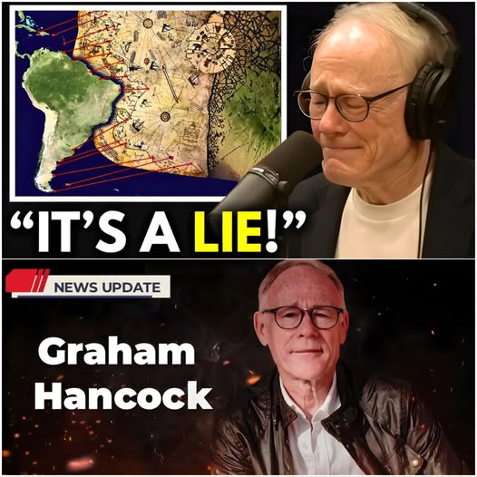
The Piri Reis Map: A Corner of Paper That Won’t Behave
Most people have never heard of Piri Reis, an Ottoman admiral and cartographer who drew a world map in 1513.
Only a corner of that map survived — a ragged piece showing parts of Africa, Europe, and the Americas.
And yet, this shredded fragment has become one of the most controversial artifacts in alternative history.
Why?
Because Piri Reis didn’t just draw it and call it a day. He left notes — handwritten, arrogant, confident — explaining exactly what he did.
He claimed he based his map on more than 100 older source maps, some allegedly copied from materials rescued after the destruction of the Library of Alexandria.
That’s where Hancock’s eyes light up.
Because if ancient knowledge survived the burning of the greatest library on Earth… then civilization didn’t simply “start over.”
It inherited secrets.
And according to Hancock, this map contains details that shouldn’t have been possible in 1513 — especially one technical nightmare:
Longitude.
Latitude is easy by comparison. Sailors have been estimating it for centuries using the stars.
But longitude? That’s the hard one.
To get longitude accurately, navigators needed precise timekeeping, something history says didn’t truly become practical until the invention of the chronometer centuries later.
Yet Hancock argues that the Piri Reis map shows relative positioning that looks disturbingly close to modern mapping standards.
A retired navigation historian once called maps like this “a problem child” in the history of cartography — because they’re not just wrong in an ancient way.
They’re wrong in a modern way.
And that makes them difficult to laugh off.
The Antarctica Problem: How Do You Draw a Continent You Haven’t Found Yet?
Then Hancock drops the detail that always hooks people who thought they were immune to conspiracy.
He points to later maps — the kind you’d assume would be more accurate, because they’re closer to the modern age.
One example: John Pinkerton’s world map from 1818.
It’s neatly drawn, based on the best navigational knowledge of its time… and yet it contains a glaring absence.
No Antarctica.
Just a blank void at the bottom of the world.
Because in 1818, Pinkerton’s civilization hadn’t “officially” discovered it yet.
That discovery came around 1819, and only after that does Antarctica start appearing confidently in mainstream cartography.
But here’s Hancock’s bombshell:
Antarctica appears repeatedly on much older maps — in roughly the right place — and sometimes in a shape that looks closer to an Ice Age version of the continent.
It’s one of those claims that instantly splits a room.
Skeptical scholars roll their eyes and say old maps are full of errors, distortions, and artistic guesses.
Supporters respond: Fine, then explain why the guess is often in the right place.
And once that question lands, it doesn’t leave easily.
A geographer I spoke with once described it like this:
“If it’s a coincidence, it’s a very inconvenient coincidence.”
Greenland Under the Ice: The Detail That Makes People Go Quiet
But Antarctica isn’t even the creepiest part.
The creepiest part is Greenland.
Hancock claims that some old maps portray Greenland not just as a blob of land, but in a way that resembles what Greenland looks like beneath its ice sheet — a contour we only began mapping seriously with modern technology in the 20th century.
Now, to be fair, mainstream researchers push back hard on this point.
Many say the resemblance is exaggerated, that people are “pattern matching,” and that ancient cartographers sometimes combined rumor, sailor stories, and guesswork into composite coastlines.
But Hancock’s argument isn’t only about perfect accuracy.
It’s about the direction of the error.
If older maps were simply guessing, you’d expect them to be less correct than newer ones.
Yet in this narrative, some older maps seem to contain oddly advanced details, while newer maps sometimes look blank or hesitant.
That’s why Hancock calls it a “knowledge inheritance” — not a straight line of progress, but a lost archive.
One cartography expert put it bluntly:
“History assumes knowledge improves with time. These maps suggest knowledge can be lost.”
That idea — knowledge being lost, buried, or ignored — is what makes Hancock’s theory feel dangerous.
Because it implies civilization’s timeline may not be a ladder.
It may be a cycle.
The Island That Should Be Underwater
And then comes the detail that makes this story feel like it belongs in a thriller instead of a classroom.
Hancock points at something drawn off the east coast of North America — an island with a strange “road” of megalithic shapes running down it.
He argues that this corresponds to the region of the Grand Bahama Banks — near where divers later discovered the infamous Bimini Road in 1968.
The Bimini Road is still debated: natural formation or man-made?
But Hancock’s point is different.
He says:
“I don’t care whether it’s natural or man-made… the mystery is it’s shown above water on that map.”
Because if it truly corresponds to that location, and it was drawn as exposed land…
Then whoever mapped it might have seen it when sea levels were lower — potentially thousands and thousands of years ago, back toward the end of the last Ice Age.
That’s where Hancock’s voice changes.
He stops sounding like a man pitching a theory.
He starts sounding like a man pointing at a locked door and saying:
“Someone was here before us… and they knew the oceans.”
The Accepted Story vs. Hancock’s Story
The accepted story says humanity didn’t become true long-range ocean navigators until the Polynesian Expansion, roughly 3,000–3,500 years ago.
That story is not insulting — Polynesians were extraordinary navigators. They crossed impossible distances and found islands that seem nearly unfindable.
But Hancock asks a blunt question:
If we know ancient civilizations like Egypt built boats 4,500 years ago, why do we act like no one ever tried the open ocean earlier?
And more importantly:
If there is DNA evidence, strange artifacts, and ancient maps hinting at older contact — why is the default response always dismissal?
To his critics, Hancock is building castles on ambiguity. He’s stacking “maybe” on “maybe” until it feels like truth.
To his supporters, academics are guarding a timeline so tightly that they refuse to see what’s right in front of them.
A mainstream archaeologist told me once:
“Extraordinary claims require extraordinary evidence.”
A Hancock supporter fired back online:
“And we have extraordinary evidence — you just won’t look at it.”
That line spread like gasoline on social media.
Why This Story Is Going Viral Right Now
Because people aren’t just debating maps.
They’re debating trust.
In an era where institutions have been wrong, slow, or dishonest about plenty of things, Hancock’s argument hits a nerve:
What if the story of human capability has been artificially narrowed?
Not necessarily by a single villain twirling a mustache…
…but by a cultural system that rewards safe explanations and punishes disruptive ones.
And you can see that tension in real-time online.
One viral comment read:
“If the Piri Reis map was based on older source maps, then history isn’t missing a page — it’s missing a whole book.”
Another said:
“This is why they don’t teach us anything real.”
Meanwhile skeptics flooded threads with the opposite tone:
“People want lost civilizations because reality is boring.”
“Old maps are full of errors — you’re cherry-picking.”
And then someone replied with the line that sums up the entire war:
“If it’s all wrong… why does it keep landing near the truth?”
So What’s the Most Reasonable Explanation?
If you pull away from the drama and look at it like an investigator, there are a few possibilities:
 1) Old mapmakers used real older sources — some surprisingly good
It’s very possible Renaissance cartographers had access to older Greek, Arab, or even Roman geographic knowledge that was more sophisticated than most people assume.
2) Some “accuracy” may be coincidence or reinterpretation
Humans are excellent at spotting patterns, especially when the story is exciting.
3) The controversial coastlines may reflect guesses + real sailor reports
Early maps often blended fact and speculation without clear labels — what we now interpret as “hidden Antarctica” may be artistic distortion.
4) Hancock could be right about one thing even if he’s wrong about others
History is rarely “all true” or “all fake.” Sometimes the real story is: we underestimated ancient people, even if they weren’t flying satellites over Greenland.
That last point is where even skeptics quietly agree.
Ancient humans were not simple.
And the last 20 years of archaeology has repeatedly shown that advanced planning, long-distance travel, and complex societies emerged earlier than older textbooks suggested.
So Hancock may not “flip the world upside down.”
But he might be forcing experts to admit:
The past is bigger than we were taught.
The Real Reason These Maps Terrify People
Because if an Ice Age mapping culture existed — even in a limited form — then everything changes:
-
Human navigation starts earlier
-
Cultural contact starts earlier
-
The story of “civilization rising from nowhere” collapses
-
The idea of forgotten high-skill societies becomes plausible
-
And the world stops looking like a simple timeline and starts looking like a crime scene — with clues scattered everywhere
That doesn’t prove Atlantis.
But it does prove something else:
We don’t know as much as we pretend to.
And for a civilization built on certainty…
that’s the scariest part of all.